THE CREB TRACK ... qld
- Woolgoolgaoffroad
- Feb 16, 2021
- 6 min read

Around the country there’s some hard 4wd tracks, iconic tracks, and also several hard tracks that are also iconic. The Creb Track in far nth qld is one of these. Known around the world for its challenges the Creb is not to be taken lightly when the going gets tough.

Originally cut in as a service access trail for the old Cairns Regional Electricity Board (CREB), the CREB Track is one of the country’s most challenging four-wheel-drive adventures, passing through World Heritage-listed rainforest as it weaves its way north from the Daintree village to the Aboriginal community of Wujal Wujal up near Cooktown.

But take note: this is a rough and ready track, suitable for experienced 4WD drivers only. A speed of between 15 and 20kmh is advised due to the terrain, narrow tracks and obstacles along the way. You will also need to check that the road is open as more often that not it shuts during periods of rain due to the dangerous conditions.

Now I’ve driven a stack of 4wd tracks around the country but completing the Creb was pretty special. Covering nearly 74km its not to be taken lightly with steep hills up and down, the narrow tracks where you cant see around the next corner or over the rises, multiple creek crossings ( which are great for a swim ), then throw in stunning views and its a recipe for one of the best 4wd adventures around. Coffs has a track similar to the Creb ( named Morbid Trail but only goes for about 5 km ), so by doing the 70km it was like a never ending 4wd track and adventure.

While the CREB Track generally remains dry during the open season, rain here can be sudden and unpredictable, so prepare for the worst and bring all the necessary recovery and communication equipment. The slightest rainfall (even if days old) can render the track treacherous or nearly impassable as grip levels plummet and the clay turns to mud. Make sure both vehicle and driver are prepared, with high-quality A/T or mud tyres and supporting recovery equipment should the going get sticky, after all this is tropical Australia.

Starting off at the southern end at Daintree village ( great place to grab a coffee and cake ) its a great drive to the start of the Creb passing through valleys with the mountains towering behind seeming like they are watching your every move. Sign posted at the start its straight into it where you’ll need to drop your tyres and cross the upper reaches of the Daintree River before heading across lush green paddocks and into the abyss of the rainforest. Massive rainforest trees overshadow the cows in the paddocks as you follow the Daintree river inland.

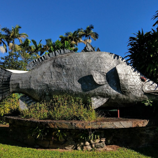
At the Daintree village have a wander around the handful of shops, find the big Barramundi and take a stroll down to the river where you may see a resident croc, and this is were the croc tours start from cruising the river. We did it last year and they guarantee to find crocs - we saw 5 on the tour.


Theres no right or wrong way to tackle the Creb so its extremely important to be wary about something coming the other way especially when the track gets pretty narrow in most places. The signs say trailers not recommended and with all my experience Id be a little hesitant, especially with on coming traffic and the uncertainty with the conditions along the way.

Do your research before hitting the Creb with weather conditions as the track gets shut down and the gates get locked - there’s huge fines for driving on it when its shut. Bit of advice too - put your UHF on scan to listen for any other traffic, I was surprised that there’s no dedicated channel for the Creb like other tracks around the country. We did encounter a few other 4wds and bikes - and luckily where we came head to head there were pull over spots.

The first part of the track follows the base of mountains before it seems to head uphill forever where over every rise you get glimpses of the track up the next hill in the distance. The rainforest hugs the track yet at certain spots the views are nothing short of spectacular. Phone reception is patchy along the track, of course better on the higher sections but definatly cant rely on it if you get into trouble.


Tracking through the rainforest was pretty special where tree ferns line the track in the cooler shady sections, dwarf Tibouchina’s with their stark purple flowers give colour against the healthy green thick forest sections. Tall vines seek sunshine growing up the variety of unique tall timbered rainforest trees. Some strangler vines and others with razor sharp spikes that will have you swearing for days if you get stabbed. Stunning old growth figs grow tall that have been here for hundreds of years.

When I hit the track I dropped my tyres down to 20 ( 285/75/16 ) but of course its a personal choice depending on tyre type, driving ability, 4wd etc. The track was tacky in parts but definatly no where as hard as I thought or was expecting ( it did rain a week prior ), yet on the higher parts the track was dry.
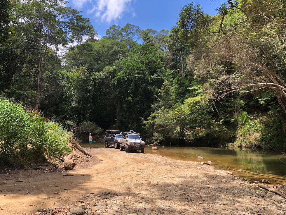
Stopping at the creeks was a great way to stretch the legs and even have a dip - don’t worry there’s no crocs up here, as well at Telecom hill that is the highest part of the Creb with stunning views. There were quite a few side tracks that were extremely challenging and looked liked parts of the original track, but after years of erosion, big tyres there are bypass tracks.

Heading to the north of the track, it slowly changes from thick rainforest to a dry Eucalypt forest environment, also known as sclerophyll forests where gums are scattered with a level of dry grass and other smaller plants at the base. When we did the track this northern part was very dusty and hadn’t had rain for quite some time.

Heading downhill out of the official Creb area there’s a great diversion into the Roaring Meg Falls area. But be warned this is owned by the local Buru people with several small communities along the way, so respect the signs and slow down when passing. Sign posted off the main road its a dry, dusty and slow trip into the falls.

The isolated location of Roaring Meg Falls makes it a perfect spot for camping with its spectacular views of the Far North Queensland tropics. While camping is allowed in the area, you will still need permission to visit or camp at Roaring Meg Falls. The land is of cultural significance to the Eastern Kuku Yalanji (Buru) people, so out of respect for the traditional owners of Buru, visitors are asked to contact a representative before accessing the falls. Contact Burungu Aboriginal Corporation.


At the carpark there are several walking tracks to parts of the river to cool off, we were hoping to see the falls but they are an hour walk from the car park according to the signs. Leaving here its a pretty easy drive back out towards Wujal Wujal, where in sections the road is being sealed for the locals plus on the last huge down hill section into town the road has been concreted with cuts to provide traction heading up.

Wujal is prominently an Aboriginal community but does have a small supermarket. If you’ve got time - and just 5 mins away - head south to check out the stunning Bloomfield Falls. You’ll see from hundreds of years of water pumping over the cliff just how it has cut its way through the valley. When we visited there was a croc warning from the locals.

So after spending a day on the Creb. What do I think ?……
Well, I cant wait to do it again, next time maybe go from north to south experiencing a different side of on of the most iconic tracks in Australia and definatly one of the top 3 tracks in Cape York. Online there’s a couple of good websites where you need to watch re track conditions and closures. When we tackled the Creb, I must be honest where all I saw online was so many 4wds in trouble up the hills and off the track because of the thick red mud that looked like claggy glue and near impossible to get out.
And how long ? ... well it took us 5 hours exploring along the way.

Ironically we did see several wrecks and body parts ( not real body parts but off other 4wds ) along the way. At the end of the track at Wujal Wujal, you can keep heading north to the stunning area of Cooktown or head south along the Bloomfield track passing by Cape Tribulation and catch the ferry across the lower region and croc infested Daintree River.
But that's a story for another time.


Comments