TASSIE NE explore
- Woolgoolgaoffroad
- Oct 16, 2020
- 7 min read

Tasmania’s full of stunning scenery, has an array of history and some bloody great 4wding to boot. I wanted to try and get to the NE corner on this trip from Hobart totally offroad, and with a few snippets of local info I did just that.

My main starting point was Sorell just out of Hobart where there’s plenty of decent supply shops for food and fuel. I was given a tip that if I headed 20 km up the Tasman Highway and found Woodsdale Road that’s where I could hit the dirt and stay there to the cape.

An easy and scenic run up to the bitumen to the turn point and this got me in to the groove for the trip. Woodsdale Rd is a well used dirt road to farms, a few wineries and in to the forest, nether the less I was on the dirt for the journey. Passing alongside Prossers Ridge line and turning across towards Mount Hobbs it was typical bush I was used to on the mainland with great views and the anticipation of what was in store for the next few days.

A local told me about the Swanston Track and where it followed the northern side of the Buckland Military training area. It's a pretty easy track to find at the end of Swanston Road. Its was interesting that where I crossed Little Swanport creek was the old convict transit town of Swanston.

Nothing more these days than a sign indicating that it was here back in 1830 that convicts were rested on their way from Little Swanport inland to Oatlands some 40 km further west where they were put to work in the rich farmlands. Oatlands has over 150 sandstone buildings and is one of the oldest settlements in Tassie.

The Swanston Track is around 30km long and is a great challenge in the dry as it follows the military property but you need to adhere to all the warning signs along the way.

The track is regarded as hard and you need to allow up to 3 hours as its a combination of steep rocky climbs, bog holes and there’s several steep switch back creek crossings thrown in, I won’t say that it was too hard BUT I wouldn’t recommend it for a soft roader as you'll need some decent ground clearance and proper low range.


The track ends at Little Swanport where I had to head north on the Tasman Highway for just 5km before turning left onto McKays road. A lot of dirt roads in Tassie are working roads and this was no different where logging operations were underway, but in most cases the main roads are open with care.

One thing I found down here in Tassie were the amount of waterfalls due to the high rainfall and steep terrain on the island, and one that I found was lost Falls about 50km along McKays Road. Its a 10 min walk in from the carpark but well worth the effort, where the water tumbles over several drops weathering away the Basalt rocks.

Crossing over the Leake Road intersection back onto the dirt Meetus Falls was another port of call and a blaster of a stopover where it's one of the taller waterfalls on the island along the Cygnet River.

One of the great things about Tasmania are the amount of free camps and along the way on this explore there were stacks in the forest, lakeside or close to the coast. McKays Road continued for about 60km with Douglas-Apsley NP on one side and pine plantations on the other. I fount no matter what direction you looked in there were tall peaks and its said that in winter you'll need wheel chains due to icy roads.

Up the end of McKays I took a left onto Valley Road where again mountains lined the road until they gave way down to the Break O’Day plains which were rich farm lands like something out of an English movie where stone walls and twisted trees used as windbreaks allowing the livestock to graze in the thick green paddocks.

I had to turn right onto Main Road but its only a short 11km tar section before heading north onto Barnes Road and further north to Evercreech Road and Mt Albert road. These are great but narrow roads where plantains of Cyprus Pine and Blue Eucalyptus forests are grown for sustainable harvesting.

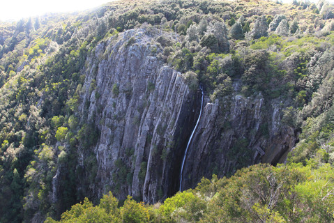
Just near Pyengana I wanted to checkout St Columba falls which are the second longest in Tassie with a single drop of 90 metres and certainly wasn’t disappointed with its short walk to the falls along a tree fern lined pathway.

The whole valley is rich in history that dates back to 1875 when the Cotton family ( mum, dad and 10 kids ) settled in the valley to setup life as farmers. The story goes that their boys were more invested in drinking than farming and as years went on as the town grew more people were socialising at the family home, so instead of building a hotel, the boys simply licensed their family home, and it was known as the Columbia Falls Hotel, but these days its known as the Pub in the Paddock. If you read the signs near the falls and follow the directions you can still see remnants of the 45km water race that was once used for getting water to the Tin mine near St Helens.

Leaving Pyengana and across the highway I headed up Anchor Road towards Lottah, but again it wasn’t long before another waterfall, namely Halls Falls was another stop. Halls Falls didn’t disappoint with its wide drop over the rocks. Just above the falls is a man made weir which remains from a time when Chinese miners worked tin during the 1880s.

One of my goals on the trip was to find the Anchor Stamper and by following the rough map near Halls Falls carpark its another 30 minutes upon the road through Lottah. This area was so rich in Tin that by the mid 1800’s it was regarded as the largest in the world and locals called the area “The mountain of Tin”. A short walk to the mind-blowing stampers had that wow moment where as you read the achievements and history of the area had me shaking my head. The Anchor Mine Company had the largest water wheel in Tassie, 20 metres in diameter and around 20 tonne in weight, but there was an inadequate water supply to run the wheel at full speed so only they could only run 30 of the 40 stampers on site. Over the years the mine had several owners with a varying degree of success.

In 1904 aerial haulage was installed to replace the horse drawn system up to other mines above the processing plant but 10 years later the mine closed. Further attempts have been trialled to re-open and profit from the mine right up till 1996 but unfortunately producing no profit. The last owner couldn’t remove the last two stampers so they have been left as a memorial to those who pioneered the area.

Along the walking track you can still see old trolley carts, wheels and one of the dams. Up the road in the Blue Tier Reserve, this was once the mining hub where a small town called Poimena survived after Tin was found, the thick rainforest was cut down, creeks were sluiced for the water but the Tin soon ran out and by 1954 the last building was moved down to St Helens.


Counsels Road that leads north from Poimena soon turned in to Tebrakunna Road which are simply good touring dirt roads. My goal was to stay on the dirt all way to Cape Portland but I heard of an unusual blue lake nearby so at the end of Ogilivies Road I trundled along Gladstone Road to the lake.

The lake was once a Tine mine that littered the area but has been filled with water and can be accessed for swimming and kayaking. The iridescent blue colour is from the rich minerals that are in the white clay that line the lakes shores and base. Back to the dirt and its an easy drive through the forest following the Great Musselroe River and even through here there’s evidence of the mining days with deep open cut mines and relics.

At the end of the road there’s two options either to the east coast or to the very top. Towards the east coast and Mount William National Park its a good hour trip through farmlands until you enter the park and by heading out along Eddystone Point Road there’s more history to explore.

Back in 1642 Abel Tasman sighted this coastline but couldn’t map it correctly due to bad winds and rocky outcrops. It was the late 1800’s when the lighthouse was finally built from local pink granite along with several cottages.

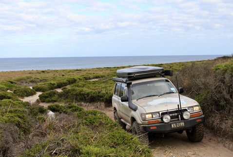
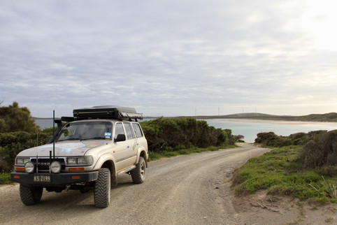
Heading north to Cape Portland the road traverses typical coastal plains with windswept trees leaning to one side and low growth scrubs that have adapted to the conditions. Midway to the top Rushy Lagoon farm holds most of the land. This mega property runs thousands of sheep and cattle, has a small community to manage it.

Also dotted on the landscape are several wind farms all collecting natural energy and converting it into usable energy. At the end of the Cape Portland road camping at petal Point is pretty special with windswept ocean views toward Bass Strait and has beach access along Ringaroomba Bay. On the eastern side of the Cape, camping is permitted at the Little Musselroe bay area which is on the entrance to the Musselroe River.

So after a little local knowledge and digging around with some maps I managed tackle the drive that normally can be done on the bitumen in just 5 hours, but offroad its a 4 day explore seeking out the waterfalls, mine relics and maritime history. I just wonder what else I missed.


Comments