KAKADU EXPLORE ... NT
- Woolgoolgaoffroad
- Aug 20, 2021
- 7 min read

Kakadu, most agree it's the pinnacle of National Parks where living cultures of the Aboriginal people have lived for thousands of years, where an abundant of wildlife all within a stunning landscape. Just getting too Kakadu can be a journey in itself being the most northerly easily accessible NP in the NT.

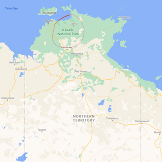
Today its vastly protected and heavily commercialised in some ways but that’s a good thing to protect this ancient landscape and culture. Covering a staggering 20,000 square km its the largest NP in Australia tucked between the East Alligator and the Wildman Rivers who’s tributaries feed out through the park.


Now heritage listed with UNESCO for the diverse natural values and attractions and the living culture. Kakadu has a complex ecosystem for its huge range of flora and fauna, some found no where else in the world. In fact 1/3 rd of Australia’s bird species is found here.


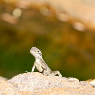


Biodiversity within the park is huge and has some pretty amazing stats.Get this; over 2000 plant species, 26 different types of frogs, 120 reptile types, nearly 70 different mammals, 300 types of fish and a an impressive 10,000 species of insects. Of course Kakadu is known for its huge amount of crocs where its estimated there are three crocs in every km of water within the park, then add the billabongs and swamps.


But within the Alligator river studies show there are 15 per km making it the most populated in Australia. Both the freshwater and saltwater crocs live in Kakadu and the warning signs are everywhere for a reason.


Kakadu comes from the Gagudju language which was established in the twentieth century in the Northern end of the park, altho other traditional languages are still used today. Traditional owners have been using this park for nearly 65,000 years dating back to the last known ice age and this is evident through the ancient rock art depicting extinct animals through to early trading sail craft off the coast. We’ve been to a host of different areas where rock art is prevalent and Kakadu TO’s allow taking photos of their amazing rock art in old living areas through out the park.

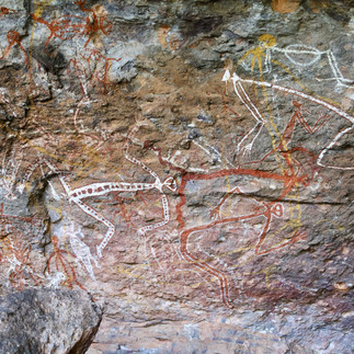


Commercialisation has kept the park under control and clean as operators work extremely well with the TO’s. The tours within the park feed visitors to beautiful sites that highlight areas such as croc and buffalo infested billabongs, a maze of rock art sites, several waterfall gorge walks through to well organised camp sites. One of the best places to see stunning examples of rock art is at Burrungkuy or the Nourlangie region to the SE.


There are many walks here for all ages with platforms to allow great viewing into the rock overhangs and caves. Signage dictates some pretty power stories of dreamtime and the Rainbow Serpent being created within the park looking after the countryside and through translation is still alive today and should not be disturbed.

The Burrungkuy circuit is the most popular around the rock art galleries up to Kunwarddewardde Lookout where views towards Savannah woodlands and several escarpments will have you looking in awe. Other walks, or hikes, take up to 6 hours to complete and are only recommended for the most experienced.

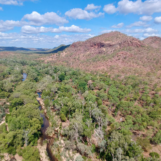
But wherever you look the rock formations are nothing short of amazing, from plated rock sections, huge sandstone cliffs through to solid rock towering blocks.Kakadu is a park that has seasonal closures each year where rivers flood across the plains, cyclones often pass through the area to rivers and waterholes that might have to have a crocodile removed and re-homed for safety reasons. The sheer vastness of the park can really only be seen by air or by spending up to a week exploring the different areas of the park with a 4wd.


Basically the park can be broken up in to 7 different sections making it easier to explore. Several sections highlight rainforest through to stone country, lookouts and waterfalls. It's said that people need to sit, relax and feel the spirits of the home country and soak up the amazing atmosphere.


During the cooler months, fire is used extensively to control long grass and give new life to the area. Ancestors have been using fire here for tens of thousands of years to help control wildfires during the warmer months from lightning strikes, it's the traditional way for conservation and it also helps with their food chain.


The main part of Kakadu is located with a giant sealed road triangle with the town of Jabiru at the peak. Jabiru is the main town of Kakadu with pretty good services and home to the nearby Uranium mine 8 km away. The mine has been supplying the world with high grade materials for decades and is in the last stages of closing down where the huge pits will be filled in and other buildings dismantled. Having a base at Jabiru it's easy to explore the outer reaches of the park but be prepared for long hauls everyday to the outer fringes.

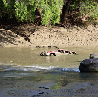
One infamous place that everybody needs to check out is Cahill's Crossing, 40 km NE of Jabiru. Known for the crocs that line the causeway waiting for the mullet and Barra to cross its a must do its nearly 50km to the coast. The tides run fast here and the Barra follow the salt water up to the crossing waiting for the push over to the fresh water. The crossing is named after Paddy Cahill who ran a cattle and Buffalo farm in the late 1890’s. The other side of Cahill’s heads into Arnhem Land where permits are needed to pass through remote and private communities. Going by the carnage of cars at low tide it gets pretty gnarly.


The park does have seasonal closures where roads, waterfalls and other features are closed or the TO’s may close off an area for various reasons and respect must be given and entry to local communities is prohibited without a permit. When we spent time in Kakadu there were several sections closed due to a high amount of water across some roads and a large croc in a popular waterhole that didn't want to leave his domain.

But a visit the Bowali Visitor Centre that’s run by Parks NT is a must for anyone for a cultural learning experience understanding, the ins and outs of the park plus gaining information on where else to explore and its here you can pay for parks pass ( free to NT residents ), camp fees to any of the managed campgrounds ( this needs to be done online but theres phone service here at the centre and also at Jabiru ). This place is simply amazing with history, skeletons, geographical rundowns, local art, artefacts and so much more.


Most 4wders that come to the park want to tackle the 50km 4wd track out to Jim Jim and Twin falls, but unfortunate when we were there a large croc and damaged river crossing still had this section closed off. But a shorter drive into the stunning Barramundi gorge and waterfall was on the list and definatly didn't disappoint.


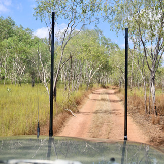
This is only a short 10 km corrugated road in with a 1km hike to the water fall and poole but is very popular with tourist companies so be wise to get in early to avoid the crowds. We were given in formation to head down to the Mary River region and the Gimbat area. Most dirt roads within Kakadu aren’t tough, just more on the rough side yet others are just average dirt roads that are cleaned up after wet season.


The Gimbat Road was no different yet for its 60km length it follows mountain ranges with distorted surfaces, past Mt Callinan and along the south Alligator River. Rock formations out here are mind blowing where layered flat plates are stacked skyward. Theres nothing seriously hard about the Gimbat track and out to the end, but with several flowing river crossings its a pleasant drive until the end where a bridge has washed away.

Along the way abandoned mines suggest a presence of Asbestos with no entry warning signs, but right beside the road an old truck weigh station is an interesting find. The rivers and mountains out here lead into Arnhem Land altho theres no access.


Another suggested drive was a 100 track that cuts through the middle of the park parallel to the northern main road. Starting out near the Alligator River crossing ( good place to croc watch ) the Old Jim Jim road get straight in the red dirt weaving through the dry scrubland littered with an array of palms, cycads and savannah bushland.

This road with remote campsites and long waterholes are popular with the serious campers and fisho’s. The Alligator River Billabong campgrounds are an alternative to get away from the crowds where most are along the riverbanks with bush camping and no facilities. There are a couple of river crossings but generally only run after the wet season ( our advice was that they were running at 600mm deep with other flooding off the plains ).


Heading past the campgrounds the roads deteriorate in to a single lane track as less traffic heads out this way, but it's worth the effort to do the next section. Massive billabongs line the track with surrounding bamboo forests along the rivers edge give it a real experience.


We were lucky to see several very large crocs on the edges of the water but quickly turned into the lagoons when they were spooked. Flocks of birds inundated the water area looking for a feed and water buffalo were common along the way.


An introduced species the Buffalo is a pest in the park damaging water courses and to the fragile eco-system. We saw damage beside the lagoons from Buffalo and wild pigs where they would wallow in the edges creating deep pits that will take years to recover.

The Old Jim Jim track intersects the Jim Jim road at the South Alligator river and its either head further south towards the Arnhem Highway or across to the Kakadu Highway, either way the Jim Jim road is a well used road.


So while seasonal closures often close off sections of the park there are always other options to tick Kakadu off the bucket list, but you’ll need a 4wd to do it away from the mainstream crowds. But don’t forget about the endless sunsets, array of wild life that are found no where else in the world, magical rock formations plus the cultural history.


Would we visit Kakadu again ?. Most definatly camping in the more remote sites, hiking to escarpment view points and of course see Kakadu from the air over the vast and intensive landscapes that time has created with huge river systems carving the landscape.


Comments