EXPLORING THE PLENTY ... NT
- Woolgoolgaoffroad
- Aug 17, 2021
- 6 min read

It's funny how the current covid conditions can change a trip, not only for us but for a lot of others travelling state to state. The plan was to head across the Plenty Highway from NT into remote areas of QLD, but with a border closure this wasn’t going to happen.

The Plenty Highway is notorious for being corrugated as hell, having bull dust holes big enough to swallow anything in its path and its remoteness for its 500km wandering route.


Not really suitable for caravans the Plenty often sees 55 metre long road trains and is closed when the rivers flood often for days at a time.

These days it’s sealed for nearly 100km from the turn north of Alice Springs across to Ovgeva Creek but when we first tackled it a few years ago it was an all dirt narrow track and took several days. It used to be just a cattle property access road from western QLD into NT but the road was improved for the general public and its slowly being improved.


Even tho the road has a state route number ( 12 ) it's still classed as a medium to hard track. Not for any tyre shredding hill climbs or winching sections, its due to the extreme remoteness of the area and theres only a couple of spots where you can get fuel and camp.

The turn off to the Plenty is 70km north of Alice Springs off the Stuart Highway eastward passing through several stunning mountain ranges into QLD, all heavily sighs posted and really cant be missed.

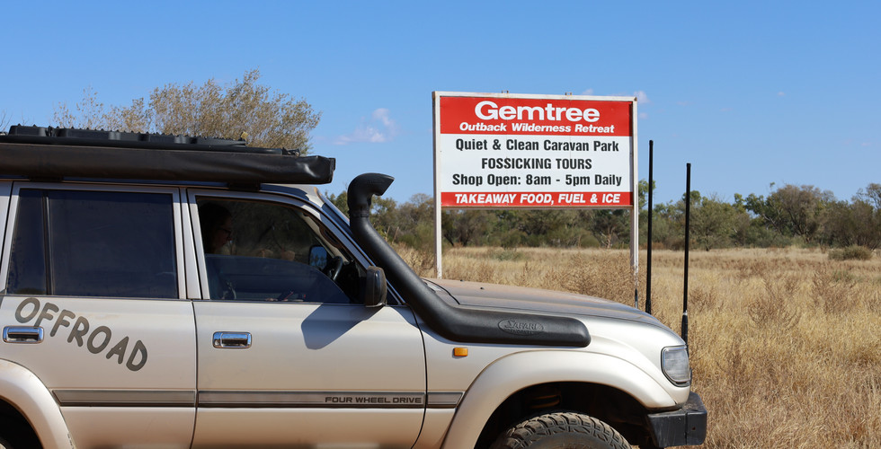
With our plan in disrepute we decided to still head onto the Plenty but spend a few days exploring the mountains, do a little fossicking for gems and hitting part of the iconic Binns Track. Our first stop was at Gemtree, just 70km along the Plenty, this place is packed full of history, they run their own store, fuel storage, caravan park and even fossicking tours.

Wind the clock back to 1885, just a few years after explorer Charles Stuart passed through, David Lindsay surveyed the country between the Queensland border and the overland telegraph line, which is around where the highway runs north-south.

A year later gold was found east at Arltunga but ran out after 30 years, but huge amounts of Mica were found at the same time. Keep in mind this was just before Alice Springs ( called Stuart originally ) was settled. Over the next few years 15 stations were taken up with pastoral leases where the present day Gemtree Park is, even property monger Sidney Kidman owned several stations nearby.

Times were tough back then running sheep or just trying to survive where the lack of water was the biggest concern. One station that had the Hale River passing by was named The Garden. On here they grew crops to feed nearly goldfield sand to supply trade the other stations.

While another station, Yambah, had their own home made drilling rig that 13 mules hauling it and in the early years they sunk 27 bores to the depth of 300 feet only finding water in two of them. Yambah Station had one of the first dams in the centre eventually running cattle, and today the station still runs with some of the best cattle in the state.

At Gemtree they have an original cottage from Mt Riddock station dating back to 1928 which they have preserved and turned into a historical museum where inside theres an array of unbelievable history inside and out.

There’s over 100 years of family and station history listed from early establishment through to good times, the extreme hardships and property maps from the early pioneers. If your hungry try one of Gemtree’s home made pies - they are to die for, not cheap, but they have at least 290g of pure beef inside. They also have a small shop if your in the area.


Our camp destination was another 30min to the east just off the Binns Track where you can free camp at the Mud Tank Zircon Field Fossicking area. This is true bush camping at its finest on Alcoota station.

No facilities so you need to be totally comfortable being set sufficient set within native bush and grass lands with stunning views of the Harts Ranges to the south. When David Lindsay ( the surveyor ) was exploring here back in 1885 he found what he thought were Rubies, and the story goes that a ruby rush happened here but later it was realised that these red stones were only Garnets.

In its hey day over 300 people trekked from Oodnadatta on foot to seek their their fortunes only to be disappointed with the sporadic gold activity at the same time.

Today, its a place on most fossickers bucket list to head to Harts Range and dig for Garnets & Zircons that have nurtured in the ground for millions of years. Most are alluvial ( found just under the surface ) so around the free fossicking area there’s dozens of shallow pits where people have been chipping away at the banks looking for coloured stones.

The Zircons here range in colours from clear, white through to pink and are similar to the Argyle Diamonds, just not as hard or expensive. One thing to keep in mind when finding these Zircons is that they have been crafted by nature and not man made ( ie cubic Zirconia ) so you're the first person to ever lay eyes on it.

In the period of the late 1880’s Mica was found in sheets in the nearby areas. Now Mica is a mineral that is soft often very flaky and today is used in makeup, cement, in the wrap that covers electrical equipment also as a heat resistant material.

Back in the day between 1880 and the close of the industry in 1960 nearly all of the Australian Mica came from this area. A short 5 min drive from the fossicking area theres an old Mica open cut mine to see. This pit is HUGE !!

While partly full of mineral based water, the enormity of the mine can be viewed from several different spots. Its hard to believe or say just how much came out of this one single pit but the nearby tailing dumps give a suggestion that it was significant for this area.


The mining here bought a diverse range of nationalities to the area, namely Italians, to central Australia creating foundations for the multicultural community of today at nearby Alice Springs. Mica was in demand during WW2 for use as heat shields but by 1950 demand slowed and cheaper sources were found elsewhere.

If fossicking for a few days doesn’t produce the nearby Binns Track is a good way to get out and about.

Now while it might take 10 days to complete the entire Binns Track that starts at the NT-SA border and travels for just over 2,220 km north, doing this section of the track is simply stunning as it passes through the ranges. Created by a NT ranger Bill Binn, it was his dream to allow explores to pass through remote and interesting areas, including desert fringes, historical areas, mining sections through to the north where Barra can be caught.


This section starting at the Zircon fields ( and well sign posted ) heads south and is named section two - East Macdonnells. Also named The Pinnacle Track it maybe only 40 km long but its diverse where as it meanders across the landscape connecting with Gardens Road.


We heading out early in the morning when the sun was highlighting the different colours on the jaggered rocky range in front of us. The mountains seemed to have a grandeur and variation of colour as well as many strangely-shaped rock outcrops that rose above us, especially as most of Harts Range is over 1000 m asl.

The first part of the Binns Track runs through Alcoota station which covers an impressive 3000 sq km. A working cattle station they’ve also had some pretty significant fossil finds. Found back in 1962 an 8 million year old megafauna area was found covering an area two football fields in size. Once a large basin they’ve found huge mammal wolf like creatures, wombats as large as a car plus many birds.


As with most outback or remote public roads that pass through stations, theres no permission to leave the road un less you have a permit or the go ahead from the owner, out here its no different. Doing this section there’s no reason to as the views are nothing short of spectacular from there road.


While it wasn’t an overly difficult track in the dry, if it was open in the wet it maybe a different story with a couple of creek crossings and a section where the water obviously uses the road as the run off. One section enters Aboriginal land and the signs are quite clear not to leave the road, just leave the gates as you find them.

Finally Binns, or The Pinnacle Track, meets up with the Garden Road. Depending on time restraints by turning left It’ll take you through Arltunga, Ross River and with back to Alice or the southern part of the Binns Track towards the border.

Our option was to turn right back towards the Stuart Highway along the Garden Road and loop back along the Plenty Highway. Sections along the Binns and the Garden Road only took an hour each to fully enjoy the scenery but its a great way to get away from camp.

This section of the Harts Range with the Zircon and Garnet fields plus the history nearby at Gemtree was certainly an eye opener and if you’ve got time spend a few days here to explore and understand the area.


Comments