Exploring Gondwana rainforests, remote camps in the Oxley Wild NP, NSW.
- Woolgoolgaoffroad
- Apr 20
- 7 min read

It’s hard to believe that a couple of hundred million years ago Australia was located in the northern hemisphere twisted on its side and up till now we have been slowly moving towards the south pole, but new reports now say that we are heading back north and in about 20 million years Cape York will be back up near the equator, all part of the Continental drift. Australia was once part of an ancient super-continent called Pangea, about 250 million years ago, but as Pangea started to rip apart during the Jurassic period, two large land masses were fragmented, called Laurasia and Gondwana.

The Gondwana supercontinent was named by Edward Suess, a geologist and scientist from Austria, in the 1800’s, he derived the name from a region in Northern India called Gondwana, and this is where Australia was located.

After the earth settled down through storms, volcanoes and ice ages, we are left what we have today with unique and strange animals and plants in bio-diverse hotspots of the ancient forests down the east coast of Australia. One of these, The New England Group is in my back yard, just a couple of hours away near Armidale NSW and there is plenty of spectacular land forms to explore through these amazing forests. This trip is all about Exploring Gondwana rainforests, remote camps in the Oxley Wild NP, NSW

I started my journey at Ebor and like most other travellers stopped at the beautiful upper Ebor Falls to stretch the legs and to check out the new viewing deck that was built after the last one was destroyed by fire. Here NPWS have been busy by installing new facilities and walking tracks to town and to the lower falls.

After the water dumps over the two falls it flows into the ruggered Guy Fawkes area and eventually finds its way to the Clarence river system that flows past Grafton. My campsite for the night was a short drive away at Cathedral Rock NP, where I was also going to hike to the top of the massive rock system.

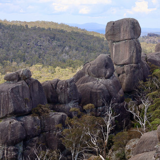
For most people its a medium hike to the rock base then a hard scramble using chains in one section to the top. The 360’ views are next level looking across farmland, forest areas and other rock formations. Basically, this Basalt rock was formed 270 million years ago below the earths surface and with volcanic activity they were pushed up from nearby dykes and Ebor Volcano, weathering has also played a big part in exposing the formations.

While there are no hand rails and barriers to spoil the view, it can be a bit daunting rock hopping across the top or as you head back down, take it easy and you’ll get back to camp safely.


I’ve camped here before and found that the nights have a deafening silence to them but as soon as the sun cracks the horizon it’s a birdlovers paradise, the notice board said over 200 species have been spotted in the park. Next on my list was to check out some old tank traps that were put on place 84 years ago during WW11.


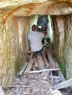


The Yooroonah Traps were part of the New England War initiative to stop the invasion of the Japanese in case they ventured out this way. They cut a tunnel under the old road by hand and made two off shoots at the end where over a ton of explosives would be place. This would be detonated when the tanks drove across the tunnel.

If by any chance other tanks went around the blast, eight concrete tetrahedra’s were placed near the lower swamp and large number of timber posts were set in the bush-land area as a preventative measure. Today they are listed by the National Trust as some of the best preserved traps of WW11 in Aus.

With a history lesson under my belt I headed a little further east to Point Lookout which is in the New England NP. Heading up mid morning the mist rolled across the area and visibility became an issue on the narrow road. The lookout area is perched on the edge of the great escapement at 1563m high and it’s hit or miss whether the misty fog clears before mid day.

On a good day in the distant horizon you can see the ocean 60km away and panoramic views across the World Heritage rainforest areas of Gondwana land. At the northern lookout you can spot the crescent of the ancient Ebor Volcano that's been weathered down over millions of years with water gushing down into the gullies and towards the coast. Within a stones through of Point Lookout there are several camping areas, NPWS huts and private cottages, these would be perfect for those who want to explore the maze of walking tracks.

Leaving the New England NP, I headed towards Cunnawarra NP with my next stop being Beech Lookout, where you can see Forest Ribbon Gums, these are some of the tallest trees in NSW growing beside Antarctic Beech Trees which are linked to the Gondwana era. Beech Lookout overlooks a gully of the Gondwana Rainforest and it’s a window into the past with remnants of the great forest telling stories of earths vegetation covering spectacular landscapes. These areas are important habitats of biological diversity that include hundreds of rare and threatened species of plants and animals.

Continuing on along Styx River Way, it’s a pleasant drive through old growth forests lined with massive tree ferns and cool climate plants and spotting several Lyrebirds darting across the road. My aim was to head to Halls Peak Campground which you’ll need a key code to access after booking online, but not before stopping at the old Styx River Forestry camp.


Retired many years ago and unfortunately been subject to vandals, the two buildings and old workshop ruins are a little history in what was a busy place. It’s free to camp here but also down in the Styx River area including Pantons Point, Hyatts and Wattle Flat beside the river. There’s no booking system, it’s first in best dressed and gets really busy during the warmer months.

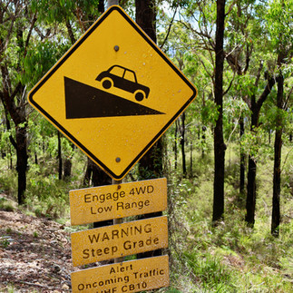
Not far from the huts is the turn to Halls Peak Campground along Raspberry Road, this has been on my radar for a while to get down and camp on the mighty Chandler River, but you’ll need to book before arriving as there is next to no phone service around here.


The drive past the gate is a very steep 2.4km narrow track to the bottom of the gorge and it was hard keeping my eyes on the road with the stunning views all the way down. The camping area sits under the silhouette of Halls Peak, which is on the right hand side driving down and also visible from the riverside camping area. It’s a huge rocky outcrop lined with mineral deposits cause by early volcanic activity.


On the opposite of the track, the Halls Peak mine can be seen scared into the mountain. Various minerals have been mined from here for many years, but has been closed off with rehab work is under way to stabilise the mountain side.

There are 13 individual camping sites, some are high on the grassy banks while others, like the one I snagged was only steps to the waters edge, NP’s do advise to watch out for rising water levels. I must say that this has to be one of the hidden gems in the New England region where it’s 4wd only and limited access past the gate.


The Chandler River flows into the nearby Macleay River and keeps going for several hundred kilometres into the ocean near South West Rocks. It’s an important tributary that acts like a environmental filter running through million year old gorges and areas like this is hard to find anywhere else in the world, it’s a natural ecosystem that provides crystal clear water and oxygen rich air for the flora and fauna that thrives in the area.

Standing beside the river and looking up at the massive gorge system it was easy to feel isolated and just realising what millions of years of weathering has created letting the river flow wildly threading its way past cliffs and rugged ridges.

For thousands of years the Anaiwan and Thunghutti people lived here and used the river not only for food but as part of their way to connect the coast to the tablelands as part of their nomadic life. Europeans came to the area after English surveyor and explorer John Oxley noted the area in 1813, he quoted “ lost in astonishment at the sight of this natural sublimity, which is perhaps scarcely to be exceeded in any part of there eastern world“ .

The Oxley Wild National park has over 500km of wild and scenic rivers, over a dozen major waterfalls and is a bio-diverse hotspot for many endangered plants and animals. Part of the Gondwana Rainforests of Australia and now inscribed on the world heritage list, we are extremely lucky to be able to explore and camp within its realms.


WHERE
Gondwana Rainforests world heritage areas extend from south east Queensland right down to the hunter region of NSW and include five different types of rainforests. My explore was into the New England group just east of Armidale in northern NSW.

ACTIVITIES
Not only can you wander through, either drive or hike, Gondwana forests, you can also visit WW11 history, waterfalls but also camp in remote and isolated areas. The Bicentennial trail meanders through the New England region which allows for some amazing remote horse riding. 4wding is permitted in the NP’s and State Forest areas and both have a different degree of trails.


OTHER INFO
The parks are open most of the year, but be aware that elevation is around the 1000m high and it gets bloody cold through the winter months, summer periods are filled with hot temps and erratic storms. Ideally the best times are late spring or mid Autumn to be able to enjoy the hikes and swimming holes. Camping needs to be pre-booked at both Cathedral Rock and Hall Peak. NPWS has all the right info on their website ( https://www.nationalparks.nsw.gov.au/ ) both parks including; alerts, camping & visitor info.
The Yooroonah Tank Traps are a raw reality what might of happened 80 years ago, detailed info can be read on the national trust site


Great article 👍 some beautiful places to camp and explore