Discovering the Davenport Ranges: A Journey through Ampilatwatja and the Binns Track NT
- Woolgoolgaoffroad
- Aug 1, 2025
- 5 min read

Updated: Feb 13
I’ve always wanted to explore The Davenport Ranges in the Northern Territory, south east of Tennant Creek, apparently they are relatively easy to get to from the Stuart Highway, but I had different plans. My journey started from the east on the QLD border where I headed out of Camooweal along Urandangi Road to eventually join the Sandover Highway.

Distances are long out here through Barkly Station but surprisingly the road was in pretty good condition for most of the way. I could hear chatter on the UHF from a chopper to stockmen that must of been mustering somewhere, but buggered if I saw them.

When I was planning this trip I knew I’d have to fuel up along the way, and my target was the Aboriginal community of Ampilatwatja, nearly 500km from Camooweal. Ampilatwatja ( pronounced um blood a-watch ), is a community of around 500 people that welcome visitors to their community to fuel up and shop at the general store.

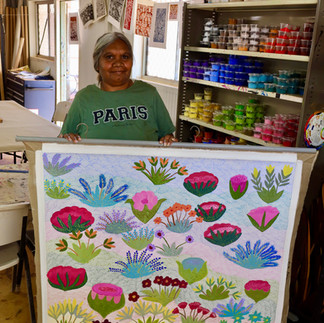
In town there’s also the Artists of Ampilatwatja who produce stunning artwork and wooden artefacts, all done by local artists. For the past 25 years they have been producing a range of art work for sale bringing the community together and regularly attend exhibitions to show off their work. Their artwork pays homage to the significance and use of bush medicine and most paintings depict traditional knowledge of what is on country. Speaking to the manager Megan and local artist Kathleen, they both love the community and how the centre brings it together.


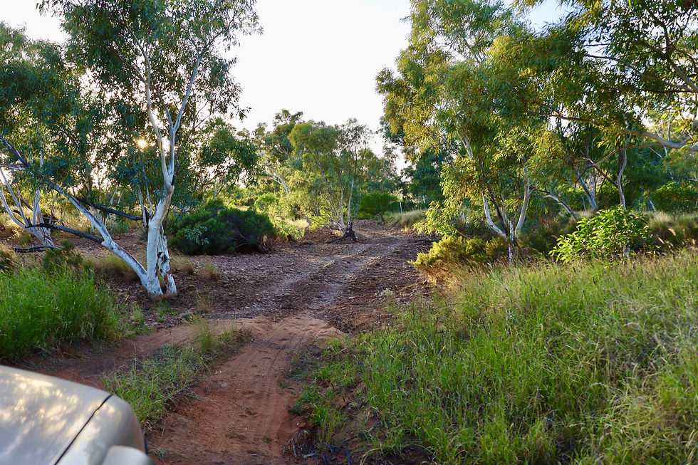
After fueling up and spending time at the centre I headed north along the Binns Track for nearly a hundred kilometres to the Davenport turn off. The Binns Track was heavily corrugated for most of the way with them being as high as my coffee cup.

The turn off was a welcome sight but it was still another 20km until the National Park gate. Now Davenport isn’t a huge park only covering 1120 sq kilometres and basically one road in and one road out. But it’s an important refuge for birdlife in the area because of the extensive waterholes and the seven species of fish that have been found here.


Most of the landscape is barren with rock strewn hills and plains, but along beside the waterholes big gums and grasses flourish giving life to what would seem a lifeless area. The Davenport Ranges also mark the boundary between traditional lands of several Aboriginal mobs, artefacts have been found and recognised relating to dreamtime stories throughout the area. I was now Discovering the Davenport Ranges.

Heading in from the south I soon came across the old Hatches Creek mine site. All locked up now, the main source of activity was mining for Black Tungsten and Wolframite which bought an influx of miners to the area in 1914, the minerals were used in hardening of steel which was in great demand during WW1.

Surprisingly, the separated materials were transported 1120km away to Oodnadatta. The end of the war saw the mine close as the minerals weren’t in great demand but WW11 and the Korean War saw a small boom, the mine never went back into full production. It was during this time that several hundred Chinese came to the area to reopen the mine and speed up the process.

From the road I could see the mine head and other gear behind the fences and across the road there was a few bits of broken equipment laying in the scorching sun. Since the 1890’s prospectors did some small time mining for gold around the ranges but nothing really eventuated.

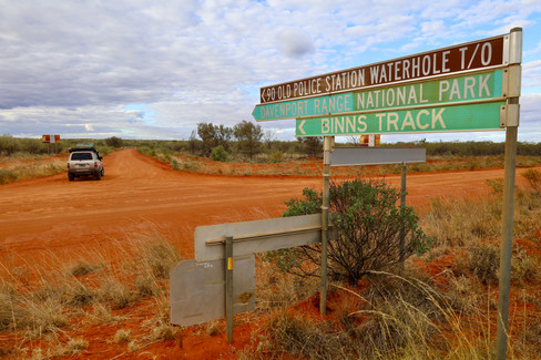
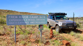
Further up into the ranges is The Frew River track which I had earmarked that headed into the Old Police Station Waterhole, but was also regarded as a tough track. The sign states ‘experienced 4wders, high clearance required with the distance of 17km and allow 2 hours’.

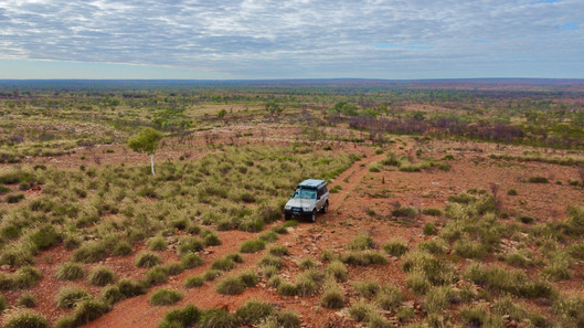
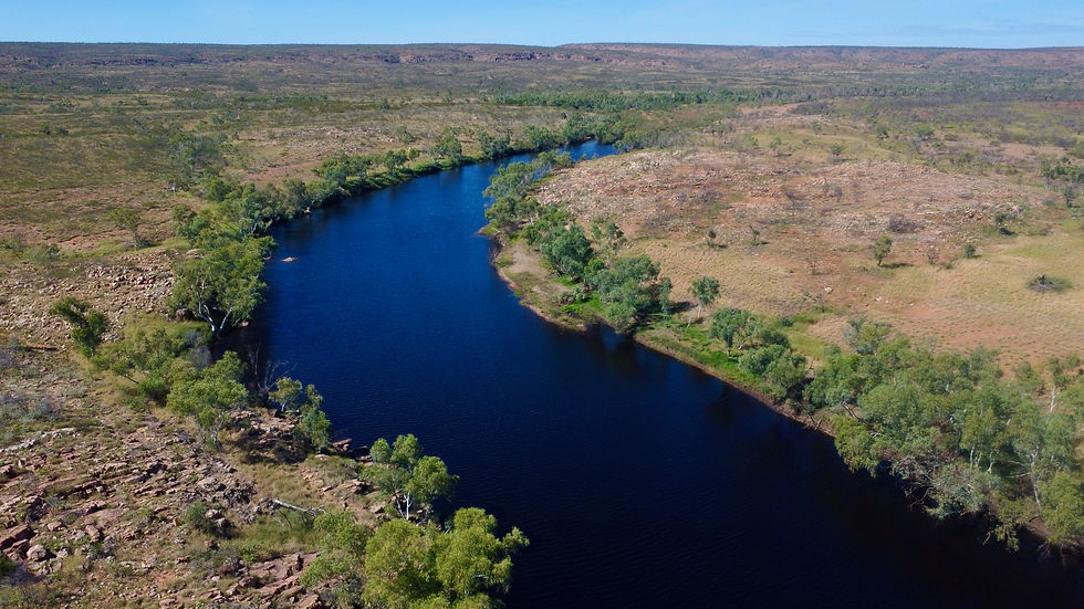
I thought, it really can’t be that bad, but boy was I wrong. This track sees no maintenance, its rocky and hard plus the dry creek crossings were sharp and steep, yep it took a full two hours to tackle and enjoy the track. The reward was arriving at the waterhole with its deep blue colours lined with stunning white gums.


Named the Old Police Station Waterhole for it’s where a Police station was built in 1920 when there was trouble between the early pastrolists and local Aboriginals. From the camping area there’s a hiking trail to where the ruins are, but due to a late wet season the waterhole was very full and I couldn’t find the track through the long waist deep grass.
Reading the info signs near the waterhole, Archaeologists have found evidence that Aboriginal people have fished and camped this water hole for thousands of years, they called it Thethew ( pronounced dut-tho ).

I camped overnight here and it was pretty peaceful until a mob of Donkeys decided to wander around the waterhole at some un-godly hour calling out to each other during the night. The next day I caught up with the mob as I headed out of camp and I think they were as surprised as I was when I popped over the rise.

The Frew Track took me back out to the main road and past Epenarra which is a small local community where they have a community shop, fuel and phone service. An hour past Epenarra a track heads into the northern part of Davenport Range and to Whistleduck Creek camping area, where there’s plenty of room to find a waterside camp.
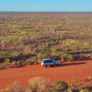
Back out to Kurundi Road, its another hour to the busy Stuart Highway and your choice which way to turn. I’d recommend heading there in either Spring or Autumn as the summer and Winter temperatures are pretty extreme. While the Davenport Range NP doesn’t have the glory of the massive gorge areas to the south, it’s a quiet place where you can get off the beaten track for a few days and away from the crowds.


WHERE AND HOW TO GET THERE
The Iytwelepenty/ Davenport Range National Park is in the Davenport and Murchison Range area in the Barkly Region, South east of Tennant creek in the NT. There are several ways to access the park, either from the west along the Epenarra Road or the Murray Downs Road. It is possible to come in from the south and along the Binns Track that joins the Murray Downs Road.


WHAT TO SEE AND DO
It’s a beautiful and peaceful place in the Davenport Ranges where visitors can relax by Old Police Station Waterhole and Whistle Duck Creek camping areas, hike to the old Policeman’s hut ruins, drive the demanding 17km Frew River Track and get back to nature. Its a remote and isolated area but this also adds to the experience. Ampilatwatja is an Aboriginal community that welcomes visitors, it has a general store and fuel, but also an Arts Centre that produce some amazing work through local artists.

IMPORTANT INFORMATION
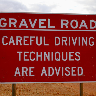
The cooler months are the perfect time to explore this area and traverse the area. Bookings are essential online to snag a waterside campsite at www.nt.gov.au/parks website as well as a NT parks pass. High clearance 4wds are recommended for the Frew River Track as there are multiple washouts and rutted creek crossings, definatly no trailers. The area is subject to flooding in the hotter months, so check current road conditions before heading to the area.


Travellers are advised to be totally self sufficient when heading to the area as its remote and isolated with no phone service in the range area. There are several communities outside the park where fuel can be bought, namely Ampilatwatja, Kurundi, Epenarra and Anmaroo to the south.


great stuff Mr Smith
Another cracking piece Kev. You never disappoint 🤘