CAPE YORK ... intro
- Woolgoolgaoffroad
- Oct 23, 2020
- 5 min read

Updated: Oct 25, 2020
Cape York, synonymous for being on the bucket list for so many adventurous, 4wders and fisherman. Its been on my to do list for so many years and after spending a few weeks in the area its got me hooked. #woolgoolgaoffroad

Some say its the last frontier where you can explore to your hearts content, now while that’s true for the hardcore, getting too and exploring the cape can be done on a budget while taking the easier routes.


Now while Cape York might seem a tad far away from Brisbane at 2,600 plus kilometres, it's more about the journey than the destination. Or is it ?. The last major port of call is Cairns where nearly every available facility is on hand to stock up on your needs.

We found that the scenery got a whole lot better as you headed north from Cairns, where the rain forest definatly meets the sea with stunning views in every direction. Theres so many spots where you can peel off to explore this coast line, so by heading along the coast through Mossman and in to the Daintree is pure bliss.

This is world heritage listed rainforest, regarded as the best and oldest in the world. Crossing the Daintree River on the ferry feels like you are going into a different world, where ancient palms and ferns line the road as it hugs the coast winding its way around steep headlands.

A stop over at Cape Tribulation is a must, where pure white sands meet palms on the beach and where the Great Barrier Reef is only miles from shore. As you head north along the Bloomfield Track ( 30 km good dirt road ) the scenery only gets better with shallow creek crossings but its here where you can stop a while and soak in the pure fresh water leaching down through the forest.

If the thought of getting your tyres dusty makes you shudder, head inland from Mossman up through Mount Lewis NP where stunning coastal views can be seen through viney rainforest pockets. Both roads lead to Cooktown where the history is amazing from Captain Cooks landing back in 1770 through to the gold mining areas that this region is known for.

Cooktown is where the real dirt starts and the roads through Lakefield NP are normally an easy drive. Within Lakefield there are a handful of great camping spots beside waterholes and river but must be booked online. Often crocs and an array of tropical birds can be spotted at most times, just be very croc wise up here as there are some monsters. The Lakefield road eventually meets up with the Peninsular Developmental Road ( PDR ) and heads straight north towards the Cape.


Along the way every couple of hours there’s always a roadhouse or cattle station that offer services like fuel, camping and food. Some of these places have been here for over 100 years and are iconic on the way to the tip.

As you head north the PDR is constantly being maintained and some sections are being tarred along the rougher spots making travelling here just a little easier. But saying that the PDR is renown for miles of corrugations that can make or break the trip.

There are a host of different camping areas along the way, some along the PDR but quite a few a bit further afield, this is where you just need to do a little research and estimate where you’ll be at the end of a days drive.

The PDR peels off to the west and heads to Weipa where the dirt continues nearly all the way to town. Weipa is essentially a mining town that was developed by Comalco but is a hub for the traveller where to relax for a few days and catch up on all things social. Some of the best fishing in the top end is claimed to be around Weipa where the rivers and bays are accessible but are made easier if you’ve got a boat handy.

Theres a short-cut road back across to the PDR but its now the Telegraph Road where long straight sections head north closer towards the tip, crossing well known rivers like the Wenlock. One iconic stopover is Bramwell Station where for some the real adventure starts. For the hard core the OTT ( Old Telegraph Track ) starts here.

This track is known all around the world for having some of the hardest 4wd sections around and at times a number of water crossings can be well over the bonnet of a 4wd. The other option is to head up the main road bypassing the ‘hard stuff’ up through the Jardine River National Park. When researching ‘doing’ the cape two must do’s are Fruit Bat Falls and Twin Falls. These are picturesque waterfalls and are a must see with a place to wash off the dust and to soak for a while.


The falls are along the Old Tele track ( but are sign posted off the easy route ) which follows the original and traditional way to explore the cape and for many years it was the only way up. The track was pushed through back in the early 1880’s with the construction of a telephone line between Cooktown and the tip, come 1987 it was partially dismantled but you can still see the odd tele pole still standing.

Both roads lead to the Jardine Ferry which today is the only way across the infamous Jardine River and with your fee it enables you to camp within national parks to the north. The ferry operates on cape York time, so don’t be in a hurry ( like most of the Cape ) to cross to the other side. From the ferry it's only an hour to real civilisation and the chance to refuel and restock.


Bamaga in the far north is full of friendly locals, amazing history and the area has some of the best beach camping around. The towns supermarket is the most northerly one in Australia and around town most services can be found.

Grab a tourist map at Bamaga and checkout the WW11 plans wrecks. They’re easily accessible for plane buffs and for anyone interested in our history and just how close an invasion came to our shores.

Between Bamaga and the the top of Australia there’s both free and paid campground camping depending on what you're after. The road to the iconic tip of Australia passes through a mixture of dry and thick rainforest but also the infamous Croc tent where Cape York souvenirs can be bought and is a must for at least a quick pic.

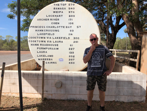
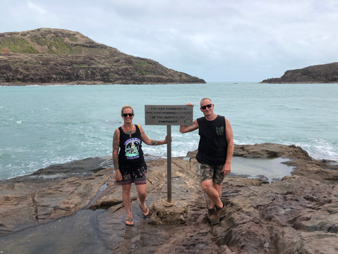
It's only a stones throw to the top and with a scramble over the rocks for a photo with the famous Cape York sign, its a welcome relief after all the travelling and effort to arrive at this destination.


But the adventure shouldn’t stop here because around the cape there’s a host camping areas across on the eastern side waiting to be explored, some with ancient aboriginal art dating back hundreds of years, others with excellent beach fishing yet others are full of solitude where sitting under a coconut tree can be blissful and its the best place to dis-connect as phone service is very intermittent in the top end.


‘Doing” the cape can be as easy or as hard as you want to make it. While you really don’t need a 4wd to explore the top end it certainly does help with some of the conditions. But we found that the more we divulged into history and maps the more we found, Cape York has some of the oldest and most fascinating history that Australia can offer.


Its hard to put in so little words and photos what an amazing place it is, how great the locals are and the sense of adventure when meeting other travellers. I know that after a month exploring the cape, we are itching to go back and discover more of what we missed.


Comments