BLACKDOWN TABLELANDS NP ... central Qld
- Woolgoolgaoffroad
- Oct 28, 2022
- 5 min read
The perception that central Queensland is flat, dry and arid is far from the truth. The weathering down of peaks and mountains, the rushing waters of insane floods that rage through the area plus time and the drying of the huge inland sea that was out here 100 million years ago reflect what is there today. Now while in our lifetime we won’t see much weathering of mountains from wind and rain, it's still happening.
One of these places with a unique landscape is Blackdown Tableland National park just over 800km NW of Brisbane. Surrounded by grazing land and some of the biggest coal mines in the world it's worth the diversion for a few days.

I started at the town of Blackwater about 35km west of the national park, which is known as the coal capital of Queensland. Surprisingly with the huge coal operations, the bulk of the mines are well hidden out of town. By huge, we are talking coal reserves of around 25,000 million tonnes in the Bowen Basin area.

Blackwater was initially set up as a town for the miners before fly-in-fly-out was a thing, today the town is relatively small considering the size of the mines. While you can’t really see the size or scope of the mines ( except for google earth ), a visit to the Blackwater coal museum is well worth the time to understand what goes on.

The museum has interactive displays, it runs across the whole process and history of the coal industry in the area plus there's some pretty cool life-size machinery parts inside and out.


All the coal and coke are transported by mega trains out from the area, so there are no trucks or machinery on the road. Just down the road, the local park flies 37 different flags to praise the international miners that work here.

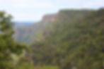
Driving east from Blackwater, a high rock plateau with imposing sandstone cliffs coloured by the morning sun screams that it is Blackdown Tableland NP. The road to the base of the park passes through huge grassland areas before the steep 6km climb to the top of the plateau.

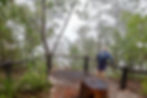
At the top of the mountain, there's a welcome site with park info boards, toilets and a short walk out to Yaddamen Dhina lookout that offers sweeping views down across Blackwater and distant ranges. Blackdown is very important to the Ghungalu people who have been visiting this area for thousands of years, the lookouts, walking trails and camping areas all have traditional names. This is one of the last areas to have phone service so if you haven’t already booked your campsite - do it here.


Munall ( Ghungalu meaning for black goanna ) camping area has 16 large sites all with fire pits, close to toilets and access to some of the walking tracks.

One of the most popular is the Goon Goon Dina cultural trail. It's a fairly easy walking track that heads around the old cattle yards beside Mimosa Creek to the Ghungalu art site.

Along the way, there are signs explaining the park's history and how the local people used the plants for food and shelter. The art site under the hanging rocks highlights different animals and plants plus there are traditional hand prints.


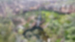
Another walk close by is the Mook Mook track that crosses Mimosa Creek and ends at the stunning lookout with views of Mimosa Gorge and Dawson Range cliffs.


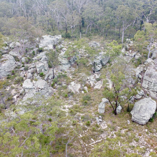
Blackdown covers an impressive 23,000 hectares and was formed when a shift in the earth's plate pushed the sandstone up from the inland sea millions of years ago, because of this the park supports a huge range of plants and animals where the tableland temperatures are cooler than the nearby plains.
The Dawson, Expedition and Shotover Ranges all converge here at Blackdown allowing for plants and animals to be found nowhere else and where isolation means they can all thrive here safely. Plants like the Rainbow Falls Callistemon, Blackdown Stringybark and two types of wattle, can be found nowhere else - when you look around, there's colour everywhere.


CATTLE ON BLACKDOWN
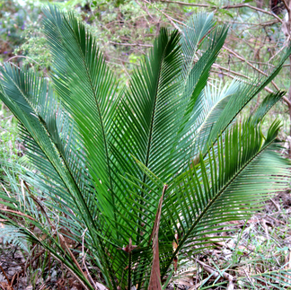
A cattle lease was granted back in 1868 to a station owner called Yaldwin who named the tableland after his English family home, Blackdown House. But even tho the thick grasses look ideal for grazing, the soils are very poor and deficient where cattle could only be grazed for several months at a time. They developed chalky bones and if they chewed on the Zamia Palms they came down lame with rickets causing them to lose control of their back legs.


GUDDA GUMOO
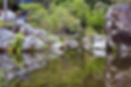
Another popular hike is to the Gudda Gumoo lookout, gorge and waterfall. It’s a 10 km drive to the parking area of Gudda Gumoo and a couple of hours' return walk but definitely one of the park's highlights. Walking down through forests of rough stringybarks, spiky grass trees and bush ferns it wasn’t long before the sound of the rumbling falls could be heard.
There is a lookout at the top near the falls, but the 240 steps down to the base give a lot better perspective of the falls and their micro-climate.
Also known as Rainbow Waters, in Ghungalu culture, the Moonda Gudda is the creator of life and the big eel that now lives at the base of the falls is the protector of the water. It's a beautiful spot to stop and just listen to what is around with the water cascading over the rocks, the breeze in the soft ferns and watching the small birds looking for insects. Heading up to the top and further along the track, huge rock pools have formed over thousands of years where rocks have ground down the soft sandstone as they’ve swirled around tirelessly.

4WD LOOP TRACK
The only other track in Blackdown is the 19km 4wd Loop Road that heads past Mitha Boongulla lookout and back to the main road. It's classed as 4wd, but apart from being a bit rough with a couple of shallow water pools on the road, there was no serious 4wd obstacles.

A one-way track that can be closed when really wet, passes some pretty impressive sandstone outcrops and cliffs with basket ferns and Blackdown Orchids smothering the lower sections.


The lookout is really impressive and right beside the road, with panoramic views of the surrounding plains and coal mines in the distance.

Blackdown Tableland NP is a quiet place to relax and explore for at least a few days. The reward is being able to bask in spectacular scenery, walk across ancient landscapes and appreciate the connection to country with the Ghungalu people through their culture. This is one special place.
FAST FACTS
WHERE
Blackwater is located 185km west of Rockhampton in Queensland's mid-north. Blackdown Tablelands National park is 35km east of Blackwater. The road into Blackdown is sealed to the top of the range, but it's a steep and windy road not suitable for big caravans.
WHAT TO SEE AND DO
Blackdown NP is all about nature. There’s plenty of walking trails from easy to hard where you can find stunning waterfalls and rock pools, views across the valleys and into gorges, walks to ancient aboriginal art, plus visit old cattle yards and admire an array of flora and fauna. There’s also a one-way 4wd track that leads you around cliff edges and past huge volcanic rock formations with lookouts along the way. Several of the walks start at the camping grounds.
OTHER INFO
Most info can be found online at www.qld.gov.au/blackdowntablelands and also to book a camping site as phone reception is extremely limited in the park. Day visitors can find all their relevant information at the park's entry signposts.