ACROSS THE FINKE ...SA
- Woolgoolgaoffroad
- Aug 5, 2021
- 7 min read

It’s funny how the weather can affect things while travelling either the best laid plans get thrown out the window and you’ll head home, or simply change the plans like in our case.

Our base to explore was the unique outback town of Coober Pedy in SA. Known as Australia’s opal mining capital with underground buildings, a landscape full of mole hills and mines it needs to be visited at least once on anybody’s travel.


History states that about 150 million years ago inland Australia was covered by a vast ocean and when it started to dry up the water and silica ( commonly called crystalline Silica, also referred to as quartz, is a common mineral, found in soil, sand, granite, concrete, rock, etc ) seeped into cracks and the earths faults.

Basically over time chemical reactions happened and opals were formed, and in 1915 the first opals were found by Willie Hutchinson. Mines the Cooper Pedy area produces 85% of the worlds stunning opal supplies, they say if you cant find colour here you're not looking.

The word got out and a year later miners rushed to the area with a town being established. Today it's a busy place with plenty of opportunities to explore the dugouts and mines and todays records state that theres about 260,000 shafts across the landscape.


Around 50% of the townsfolk live underground due to the extreme temperatures in summer, and interesting enough there’s over 40 different nationalities making up the population.


The town has the usual tourist attractions with plenty of opal shops, there's a grassless golf course, mine tours, an underground church, motels plus if you're a tent camper you can set it up underground at Ruby’s caravan park.

The town was originally named Stuart Range but this was officially changed to Coober Pedy by the Mining Association in 1922. It’s thought that the Coober Pedy meaning is what the local Aborigines saw as strange activity of 'white men down holes’.


With low rainfall the town pumps water from 25km away from a deep artesian bore after failed attempts by the government to establish several local water sources. The first program was to build a 2 million litre tank underground but was deemed unreliable, then in 1967 a de-sal plant was built to treat salty water pumped from 100m below the surface but it didn’t produce enough water for the town.

Cooper Pedy has the Stuart Highway running through it but it also has opportunities to explore the desert regions to the east towards the infamous Oodnadatta Track and our plan was to head up the Kempe Road towards Oodnadatta.

Now while Kempe Road is ‘just’ another desert dirt road the scenery is pretty mind blowing. With miles and miles of tree-less plains for as far as the eye can see with shimmering masses of Gypsum popping out of the ground its a sight to behold.

Combined with the gibber rock plains theres not much life out here or fun during the warmer months. It’s hard to imagine the early explorers trudging through here looking for water or shade back in the late 1880’s when at times they’d only travel 20 miles a day with their convoy.

The pink road house at Oodnadatta is an Aussie icon, if not for the massive burgers just visiting it is another must. Most know it as being painted all pink and from the all round road signs made by Adam Plate ( and of course his wife Lynnie ).


Tragically Adam passed away but his legacy lives on at the roadhouse and indeed along the Oodnadatta Track. For those that don’t know, Adam cut the tops out of old 44 gallon drums, painted them pink and put interesting facts on them - before placing them along the track.

The Oodnadatta track covers 620 km between Marla in the north down to Marree and is packed with history along the way, its best to do the whole track from start to finish to explore all of the heritage and unique features along the way.

Before Europeans started to explore the area and indeed start using the track, it was an ancient trail used by Aboriginals wandering from water hole to waterhole using the trail for Ochre trading.

Explorers used the route to head north to the Gulf, in fact its roughly the route taken by explorer John Stuart on his third expedition in 1859 and before the Overland Telegraph was built where nearly 33,000 poles lined the way from Adelaide northward to Darwin.

Oodnadatta has several restored buildings, a pioneer park and the old rail house is now the museum which is free to enter. It was in 1890 that Oodnadatta was proclaimed as a town and during that time millions of acres were taken up as pastoral leases.

By the end of 1891 the rail line had come to town from Warrina in the south making Oodnadatta the end of the line and it was around this time that the tough and amazing Afghans moved into the area. With their knowledge of harsh desert life as nomadic travellers they were soon moving mail, freight & passengers northwards to Alice Springs with their camel teams.

This lasted for a good 30 years until the rail line was extended north phasing out the teams. Their legacy still lives on with monuments throughout the area, descendants and other related history.

After spending a few hours at Oodnadatta our plan was to head up through the remote Witjira NP on the western edge of the Simpson Desert, via Mount Dare but recent rainfall still had this area closed off to all travellers, the only option was to head up the track to Marla on the Stuart Highway, some 210 km away.

Now while the Oodnadatta track needs to treated with respect due to its remote location, more often than not the roads in pretty good condition, as long as you drive accordingly.

Prior to our camp at Coober Pedy we spent time on the southern end of the Oodnadatta track exploring the rail heritage ruins that have easy access.

Some that are worth a mention includes the Curdimurka siding dating back to 1888 where most of the buildings, water tank, desalination boiler and the 433m long plate girder bridge can be viewed, thankfully all listed on the Heritage Register.


In 1943 a Kennicott lime - soda plant was built to deal with the high minerals in the water that was needed for the loco’s. It seems like this siding was in the middle of no-where but the settlers made it home until 1980 when the last Ghan train went through. Along most of the Oodnadatta there are plenty of ruins to be viewed, sadly some have been vandalised.

Hitting Marla and the Straight Stuart Highway we headed north towards the NT and just 20km into the NT we pulled into Kulgera Roadhouse for a fuel up and to gain current road conditions as we wanted to head east from here.

According to Kulgera they had received no rain and it only hit across the nearby Stanley Tableland. With changed plans we again hit the sandy roads along the Finke road, as the destination for the night was within the Newland Ranges and the official centre of Australia.

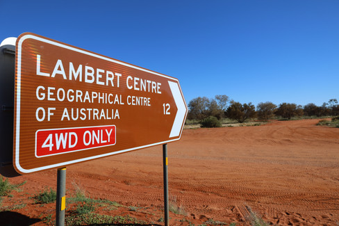


The road onto Lamberts is only 12km but was extremely chopped up taking nearly an hour, dodgy severe washouts and battling endless corrugations.

This is now known as the true centre of Australia after many others claimed to of found it. Even explorer Stuart claimed he worked it out but unfortunately his was hundreds of miles away. Explorer Madigan, who in 1930 used a crude metal cut out of Australia was closer, just 11km away.

Finally in 1988 it was declared here by the Institute of Surveyors and Cartographers after plotting over 25,000 points around our coastline and now on the exact spot theres a replica of the flag pole that sits on top of Parliament House.

After heading back out to the Finke road its another hour of travel passing by the Beddome Range before entering the cultural town of Finke. It’s here we jumped back onto our original plan that was to follow the old Ghan line 180km up to Alice Springs.
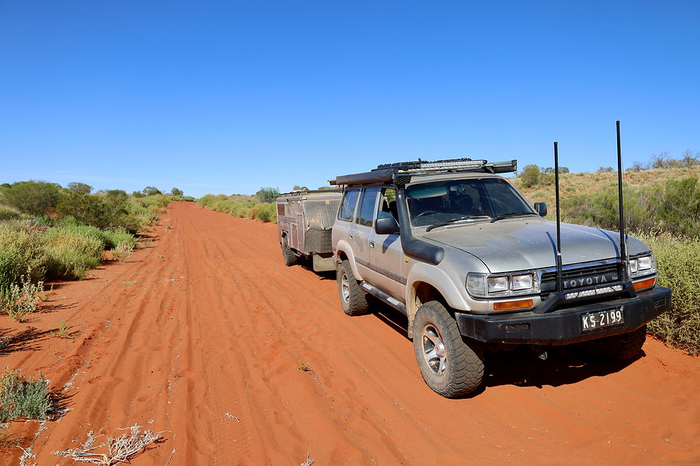
Well sign posted the track runs loosely along and beside the old rail line. Now while the track has been pulled up when it was moved further west, theres still plenty to explore along the way, as well dodge the numerous metal spikes left on the ground from the existing line.

4wd is definatly recommended as the road is mostly unmaintained with rough sections, miles of horrid corrugations, narrow cuttings and of course desert sand. The Old Ghan trail runs beside the yearly Finke race track and in parts this track wasn’t as rough as the main track.

Along the way theres several places of interest to stop at right on the track, where relics from the past lay, the buildings still stand and informative info boards tell the story behind what once was.

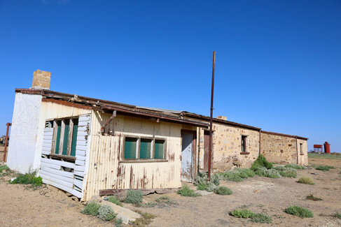
Engoordina, is the first visible stop where it was the base for maintenance crew number 22 servicing the line. When the war effort was on men left here for better pay and the government ran adverts calling for more workers to maintain the line across flat ranges, through desert oak fields and the rolling sand hills of Finke.

The only thing left here now is roofless buildings of the workers quarters with piles of sand inside blown in from harsh storms. A few relics lie outside with plenty of graffiti on the outside walls.

Further up the huge water tank of Bunbooma stands out against the sand dunes and desert trees. Another hour up the track is Rodinga, Aboriginal for foot or road; again here the ruins are just a roofless building where workers made camp out of the harsh weather that this area can have, and was the second last siding before Alice Springs.

The story boards beside the buildings ( both here and Engoordina ) tell of the hardship, history of the line and of course personal stories.

Now while the weather may of upset our direct plans the diversions we had to made were pretty cool exploring heritage and ticking more off our bucket list.


Comments