Unlocking the Kunderang Wilderness
- Woolgoolgaoffroad
- Mar 1
- 6 min read

The Great Dividing Range that extends along the east coast of Australia has left many great areas to explore as a 4wder but also holds little secrets with history, amazing views and some of the best camping there is to offer. Unlocking the Kunderang Wilderness

My trip started west of Wauchope in NSW which has a long timber history when europeans found the hills were filled with some of the best timber in the world. Now what is called the Oxley Highway that runs westward from Wauchope was named after surveyor and explorer John Oxley who blazed the trail back in 1818.

After a quick stop at Long Flat, 30km west of Wauchope I headed just up the road to the Kindee Suspension bridge which was built in 1936 that crosses the upper reaches of the Hastings River and just happens to be the oldest suspension bridge in Australia, still in use.


Heading further along the Oxley Highway, I turned north onto Forbes River Road and started my journey towards the Kunderang Wilderness area. Now the wilderness area covers nearly 150,000 hectares and has many National Parks, State Forest and Conservation areas within it’s boundaries. I was out to explore the southern section of the park, camp near an old cattleman’s hut, delve into mining history and seek out stunning lookouts while exploring the maze of 4wd tracks through the area. Unlocking the Kunderang Wilderness.

Staying on Forbes River Road I was soon into the thick of things and heading towards Mount Boss State Forest. It’s been five years since the devastating fires that ripped through this area, and even tho the bush is coming back with vengeance, the tall gums still show scaring high towards their tops. After a few hours I was deep in the Oxley Wild Rivers National Park and heading down the Racecourse 4wd trail.

Now it’s nothing too extreme out here, just narrow rough roads with a couple of small creek crossings. My end goal today was to camp near an old cattleman’s hut deep in one of the valleys, and it wasn’t long before I found Youdales West trail.


Pre-booking is essential to head down into Youdales as there is a coded NP gate for campers or day visitors to get past. At the top of the track there’s an engage 4wd sign, but to honest the first section wasn't too bad, but then the track took me by surprise as it headed steeply down, along a spur with several switch-backs. It’s a very narrow track and I would hate to encounter another 4wd coming the other way.


Down on the river flats, Youdales Hut soon came into sight with the campsites just beyond. There’s only three designated campsites to book but they all come with their own fire pit and table. Timber is supplied plus there’s a drop toilet nearby.

Youdales Hut was built back in the 1930’s by local stockman, Alan Youdale, first as a simple A frame bark hut but then he upgraded to a slab hut a few years later, and with a tin roof transported down into the gorge by pack-horse. The Youdale family had nearly 1200 head of cattle down in this gorge country for 50 years before National Parks bought it in 1986. The original hut was restored by NPWS but bushfires burnt it down in 2019. Since then it has been rebuilt to what it is today.

It’s a great insight to what life was like in this remote area, living in a two room slab hut and where Alan and his wife had six children. Every few months Alan would walk up the mountain to Walcha to sell his 3000 Rabbit skins for good money along bridle tracks, which he surveyed. The Bi-Centennial trail runs through this area so occasionally there are horses and walkers either camped or just passing through. Along the green Gully Track there other huts and stock yards.

After a peaceful night under the stars with a fire late into the night I needed to backtrack up to the gate and back out to Racecourse Trail. The forests around here ancient dating back to the Gondwana era created by volcanic activity 80 million years ago. Unfortunately when early European settlers started clearing some of these areas, little did they know they were harvesting some of the oldest forests on earth. But the area is healing since logging stopped in 1983 in the critical areas and with the regrowth there are positive signs that its well underway to survive to what it was.

I was soon in Willi Willi NP and my morning goal was the old township of Kookaburra. A mill was established here back in 1946 and it soon grew into a small tight knit town with a little school, shop and tennis court. The mill workers were a diverse group with migrants, blow-ins and boys as young as fourteen working long days. The main source of timber up here was softwoods where it would be transported by truck, 80km away to Kempsey then further away to Sydney for processing.


Fifty years ago the mill was destroyed by fire, rebuilt but then it closed in 1969. In the devastating 2019 fires the remaining buildings were again destroyed by fire, but local groups have rebuilt the old school building, placed information signs, picnic area and new toilets. With the fires going through its uncovered where the original mill was down by the creek and exposing a huge steam driven wheel and mechanical gear.

From the old mill site I headed further west along Carrai Road past thick forest areas and where selective logging had recently taken place. I soon came across the Daisy Plains Huts. These were built for the timber workers who worked out here remotely and today it’s a place where you can camp for free and use the huts if the weather turns a bit nasty. If you camp here, please keep the area and the huts clean and respectful.

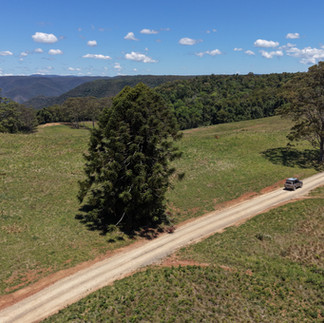
Just past the huts I jumped onto Warrick Road for seven kilometres to check Mary’s View. This absolutely stunning lookout has 270’ views into the vast Aspley and Macleay gorge area. There is a maze of over 200 000 hectares of valleys, cliffs and wild rivers that have been a special place for the local Thugutti people for thousands of years.

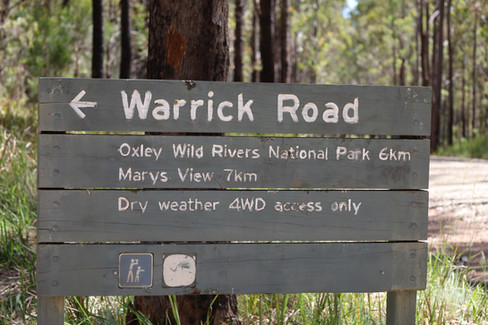


Mary’s view was named after Mary Cochrane, the wife of a logger who worked on this plateau. It’s nearly a kilometre drop to the river below and on a clear day you can see Kunderang Homestead beside the Macleay River below and the town of Walcha high on the opposite plateau. It’s a solemn place where you can just for house and just gaze into the gorge below, look for birds sailing in the wind thermals, or admiring granite rock formations.

Backtracking to Kookaburra and further down Carrai Road, it’s a scenic drive back down the mountain and onto the rich fertile flats of the Macleay area. This great eastern escarpment area is home to a unique blend of flora and fauna all protected now as a wilderness area, but still allowing 4wd access, a multitude of walking trails and remote campsites. It’s one area that will definatly have you coming back for more.

WHERE AND HOW TO GET THERE
The Kunderang Wilderness area covers National Parks, Conservation and State Forest area’s as it heads up towards the ruggered gorge areas of the Great Dividing Range, west of Kempsey on the mid north coast of NSW. Access can be obtained from either west of Kempsey or Wauchope to the south. You’ll need several days to explore this isolated area.

WHAT TO SEE AND DO
The 4wd tracks through the wilderness area range from touring tracks through to mildly challenging tracks depending on the weather and time of year. A key code is needed to access Youdales Hut whether it be for a day trip or overnight camp. There’s history up in the hills to explore, walking tracks and stunning views to enjoy. Free camping is available at Daisy Plain Huts. It's a great few days away Unlocking the Kunderang Wilderness .


RELIVANT INFO
A good gps is needed to navigate the maze of tracks in the wilderness area or use the Central East NSW paper map that overs the whole area. There are only 3 selected camp areas at Youdales Hut and you’ll need to book online for gates key code, this can be done at https://www.nationalparks.nsw.gov.au/camping-and-accommodation/campgrounds/youdales-hut-campground-picnic-area .
Further info can be found on NSW National Parks website such as road closures and other alerts.
For info on the Kookaburra mill and school, jump across to their faebook page.


Comments