"The Hidden Gems of the Pilbara: Exploring the Stunning Beauty of Western Australia's Vast Region".
- Woolgoolgaoffroad
- Feb 25, 2024
- 7 min read

Updated: Feb 18
Imagine an area of over 17,000,000 hectares to explore with ancient landscapes, coastal bliss, great 4wding, heritage listed areas plus some of the oldest rock art on earth. This area in Western Australia dates back 4.3 billion years and is twice the size of the UK.

This place is regarded as the oldest place on earth with rich deep red rock formations where the rock is so old that there are no fossil remains left in the rock. Welcome to the epic Pilbara region. It’s thought that the name Pilbara is an Aboriginal name for a Mullet that’s found in a creek off the Yule River. I was so happy to find The Hidden Gems of the Pilbara

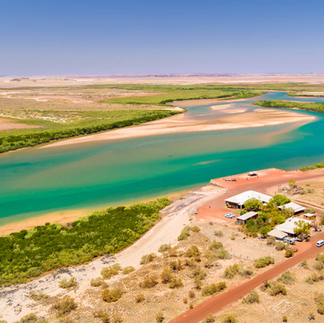
I wasn’t too sure how to tackle this vast area and wasn’t expecting to see as much as I did. I spent a few days in the southern part of the Pilbara area exploring Millstream Np and across through the mining area near Pannawonica and then back to Onslow to explore the coast.


Nicknamed ‘Cyclone City’, it has been through more than a dozen cyclones to where winds have been measured 232km/h. Originally built for pearling, mining and pastoral use, Onslow is a sleepy town that attracts tourists year-round. Officially white Europeans travelled through here in 1861 when an expedition was led through the Pilbara, but Abel Tasman visited the islands off Onslow in 1644.


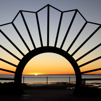


It's an interesting town with a heritage trail, free riverside camping at 5 mile, visiting old Onslow town ruins and checking out the huge salt lakes that cover 90 sq km where they produce 2.5 million tonnes of table salt a year.


Heading north to the largest and fast-growing city of Karratha, which is known for the massive ore operations in the Pilbara but also the gateway to the rich Dampier Archipelago, it has ancient rock art, but also the perfect base to explore the Pilbara region.

Established in 1968, Karratha is a busy growing city that has 40% of the region's population. Built to provide accommodation and services for the massive mine operations, Dampier salt, and the NW gas and oil projects, Karratha has a lot to offer. The Yaburara Heritage trail to the east follows steep hills around town, passes a number of Aboriginal sites and overlooks the town and out to the coast.

Other must-do’s around Karratha include a visit to the NW shelf project info centre where visitors can view models of the operation and see the gas plant domes that hold natural gas before it gets shipped overseas.

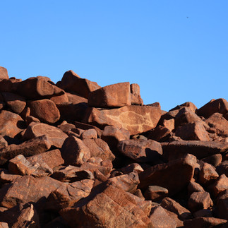
Not far down the road at Burrup Peninsular there are an estimated 10,000 indigenous rock engravings which are said to be 30,000 years old, these petroglyphs range from animals, and human shapes to extinct animals that once roamed the area. Get this, they are claimed to be the earth's oldest and largest concentrated collection of petroglyphs known to man.


Nearby at Dampier, visitors can see the huge port that was made for the mining in the area, visit the lookout and watch the 3km long trains that cart ore from the mine operations to the port ready for distribution around the world, plus visit the Red Dog statue, made famous by the movie as he roamed across the Pilbara region.

Offshore the fishing is next level and where there are dozens of islands with stunning white beaches throughout the Dampier Archipelago.


Not far north of Dampier are the towns of Roebourne, Cossack and Point Samson. Cossack was once the original port for the pearl luggers before they moved north to Broome, and with this, the town slowly died. Today the beautiful old buildings are being restored for the tourists and history buffs that visit the area.


Roebourne, the oldest settlement in Wa’s northwest has a fascinating heritage trail to explore and was once the most important town in the Pilbara before a rail line was built the Port Headland. Head out to Point Samson to wander along stunning white beaches and spot the lighthouse that was built in 1888.


HEADING INLAND.
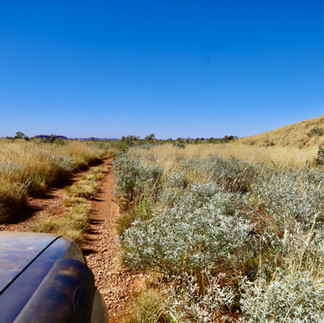
As soon as you head away from the coast, the Pilbara’s red dust gets in your skin, clothes and every nook and cranny in your 4WD. A highlight of the Pilbara is driving one of the many rail access roads and often passing the enormous 3km long ore trains that run 24/7 from the mines to the facility plants at either Port Headland or Dampier.


You need a permit tho, and they are available online after watching an induction video and answering some safety questions. Two notable and the most popular National Parks in the area is Millstream NP, where you can relax beside tree-lined pools, swim in crystal clear rivers and camp in remote sections of the park.

In the heart of the park, a homestead that was built in 1920 is open to visitors to discover the pastoral history and the Yinjibarndi people's artefacts.


Karijini NP is the second largest NP in WA and attracts visitors worldwide. Amazing rock formations, with cold pools of water that never see sunlight, dramatic waterfalls and amazing colours when the sun hits spectacular gorge walls are all part of the stunning Karijini experience, ( this place deserves a page in itself ! )


Nearby at the highest town above sea level in WA, Tom Price is another place to spend a few days. Tucked beside the Hamersley Ranges, considered one of the earth's oldest weathered surfaces, this area dates back to the ice age.

While being a mining hub, there’s still plenty to do with mine tours, conquering the 4wd track up Mount Nameless ( aka Mt Jarndunmunha ), which is one of the highest mountains in WA and where the views are to die for overlooking mine operations, the town and the beautiful Pilbara landscape to the horizon in all directions. This is def one steep track.


Nearly 300km away to the east and again on the fringe of the Hamersley Range is Newman, the largest inland town in the Pilbara. Predominately a mining town where BHP pulls thousands of tonnes of ore out of the ground every day, it's still a good base to explore the surrounding area.


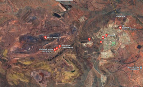
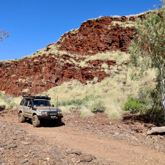
Mt Whaleback Mine is the largest open-cut mine in the world where they run tours daily into the heart of the operations and is so big that it can be seen in space. Away from the mines, the 4wd track to Eagle Rock Falls is a must where the narrow winding track heads into the hills of the Pilbara passing Kalgan Pool where volcanic rock has been pushed out of the ground millions of years ago leaving an amazing backdrop beside the pool.


Just over an hour away the tiny township of Nullagine sits idle surrounded by red granite hills, gorges and waterholes. Gold was found here in the mid-1880s but it's also known for being the first place in Australia where diamonds were found.


Heading west from Nullagine along Skullsprings road takes you to the remote yet stunning running waters waterhole where warm water seeps out of the ground year-round creating a warm waterhole. This place has to be experienced !


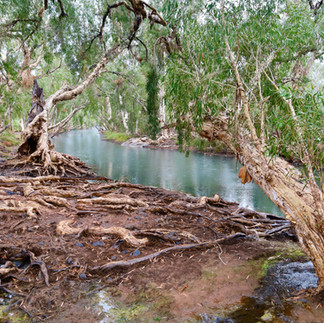


Up the road, Carawine Gorge has one of the best riverside camp areas I found in the NW Pilbara, where a massive water system is lined with sheer rock walls where the morning sun lights up in all glory. This is a peaceful place and one of the best inland camps you'll find.

My last stop was at Marble Bar, known as Australia’s hottest town, where back in 1924 the daytime temps never dropped below 100’F for 161 days straight. Today it's a quiet town after the gold rush in 1891, but this only lasted a few years as richer fields were found at Kalgoorlie.

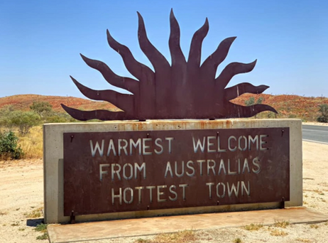


The Marble Bar Heritage Drive takes you around town visiting 18 places of interest, up to lookouts and to Marble Bar Pool at Coongan River. It was here that a rich-coloured rock was found and thought to be Marble, disappointingly it was only Jasper. When wet, the colours come alive in the rock which has been classed as some of the oldest Archaean Rocks in the world. Serious fines can be issued if rocks are stolen.

I only spent 4 weeks exploring and discovering the Pilbara where I don’t think I even scratched the surface, to me the Pilbara is the soul of the earth and where it holds hidden treasures and no matter where you roam, you’ll be pleasantly surprised with the Pilbara.


WHERE
The Pilbara region is 1500km north of Perth in WA and covers a huge 17,000,000 hectares. Landforms date back 3.6 billion years and it's known for their global biodiversity across its ancient landscape. Considering its large and thinly populated area, it's popular due to its remoteness and natural beauty plus the Pilbara is extremely rich in its mineral deposits. Major airports at Karratha and Port Headland have direct flights from across the country making exploring this area a little easier.


WHAT TO SEE AND DO
The deep rich red landscape and iridescent skies make the Pilbara a photographer's dream. There are National Parks within the Pilbara to explore, stunning waterfalls and swimming holes to cool off during the warm days, throw in coastal camps, history and ancient rock art - it's all in the Pilbara.

OTHER INFO
Both Port Headland and Karratha are the main centres in the Pilbara, both of these towns service the mining companies that operate nearby. With major shopping centres most services and shops are covered. Out in the Pilbara, smaller towns such as Tom Price, Newman, Roebourne, Dampier and Onslow have basic services for travellers and locals. Information centres in most towns can offer advice and steer you in the right direction for tours and attractions. Planning, permits and all the right info can also be found online at https://exploreparks.dbca.wa.gov.au/


Comments