


KROOMBIT TOPS NP. Queensland

Set your mind back 215 million years ago during the Triassic period when volcanic activity was rampart, dinosaurs roamed our land and when massive eruptions started to trigger mass extinction. It was at this time that these factors started to shape Australia’s landscape and especially the breakup of the super-continents around the world.

Kroombit Tops in Central Queensland was one of these places that started to form over this time, today it’s a geological marvel where the foundation of the park is rooted in intense volcanic activity. It all started when the massive circular caldera ( the depression formed when a volcano erupts and collapses) ,this crater was roughly 40km across that collapsed under it’s own weight. Over millions of years, the surrounding land eroded, but the combination of hard volcanic rock and durable sandstone capping resisted erosion, resulting in the high-altitude plateau that rises up to 940m on the Kroombit Tops.

Today, spectacular 100m-high sandstone cliffs mark the edge of the plateau that can be seen particularly along the north-east sections. Creeks have since cut into this landscape creating deep narrow and rugged gullies, allowing both dry woodland and rainforest to thrive in this unique cool climate area.
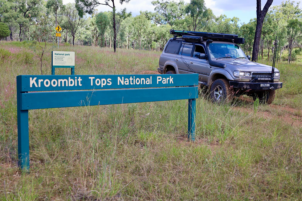
It’s been a few years since I was at Kroombit and was keen to head back but from a different direction. Last time I headed in was along the Tablelands Road from the north, that’s suitable for towing offroad trailers, but this time I wanted more of an adventure. My starting point was the little town of Monto, on the southern side of Kroombit.
Today it’s busy with dairy farms, tourism and large mines pulling out thermal coal deposits, but back in the late 1840’s gold was found and the town grew for many years. Gold was found between the late 1860s to around 1925, and the area was run by successive madams who housed, fed and generally exploited the local miners. It was estimated that 1,200 women operated ( think prostitution) in the area.
MONTO MUSEUM PAINTED COW AT MONTO MONTO SILO ART
Around Monto today, there’s plenty to see and do including visiting the Three Moons silo art just out of town, the heritage museum which is jammed packed with local memorabilia and following the interesting but quirky cow trail, that leads you around town to various points of interest. The main street has an early 1900’s feel to it with heritage buildings, a cultural centre and street art along Lister Street.

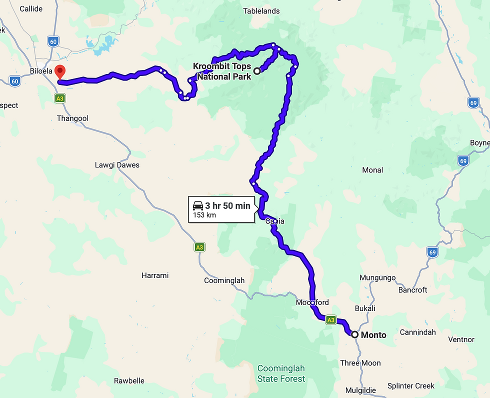
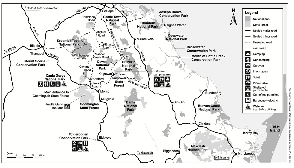
Heading to Kroombit from Monto I wandered up the Cania Road and turned off towards the locality of Moonford, an easy 67km away. The Moohan Creek Road has directions towards the park, passing through cattle and cropping properties, there are a few gates but just leave them as you find them. It’s a beautiful 70km drive heading towards Kroombit with plenty of little creek crossings and scenic views.

During the dry there’s no need for 4wd but it would change during the wet with higher creek levels and muddy hill climbs. At the parks entry it changes to Clewleys Gap Road and recommended for high clearance vehicles as there are more serious steep sections, a few blind corners and it’s pretty rutty. Queensland Parks do suggest this road is ok for offroad trailers, but nothing less.

At the top of the ridge along Clewley’s is a Kroombit’s NP info board which has a stack of park info, and they suggest that you take a photo of the parks 4wd tracks as there’s not much phone service at Kroombit. The next port of call just up the track is a Rainforest Walk. This tiny pocket is very unexpected and something you’d see along the coast line not in a dry timber forest, but it all stems from volcanic activity all those years ago leaving behind rich red soil and an array of sub-rainforest trees, palms and ferns.

Another spot to stop at is the Kroombit Tops lookout, where on a fine day you can see as far as Gladstone on the coast. There’s a toilet here, seating at the lookout and plenty of reading signs to fathom how significant this area is. The lookout provides spectacular views into the eastern escarpment looking over the Boyne Valley and down below you can see ribbons of dark green rainforest among the paler eucalyptus woodlands.

The forests of Kroombit Tops also is the southern most point where the exclusive and endangered Semon’s leaf nose bat is found (https://australian.museum/learn/animals/bats/semons-leaf-nosed-bat/ ).
This little creature is only found from here and north to the tip of Cape York.

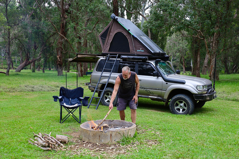
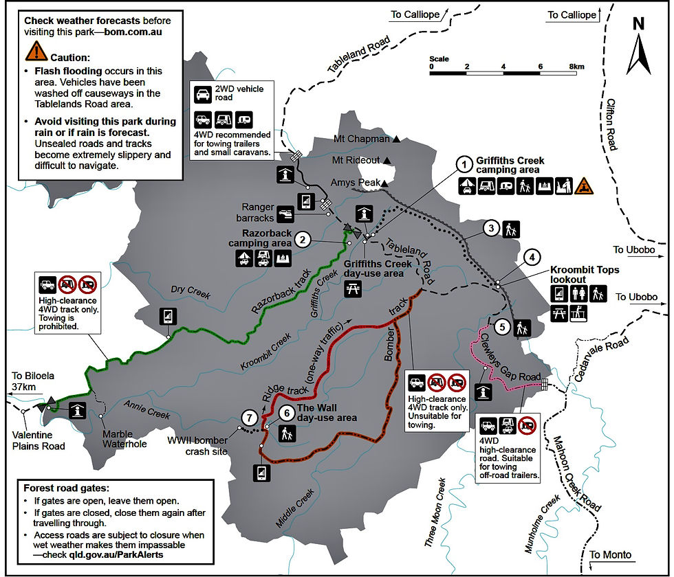
There are only four vehicle tracks through the park and the Tableland Road is the main access for the other tracks to shoot of it, but its also where the Griffith’s Creek day use and overnight camp area is, just 11 kilometres away from the lookout. It’s a peaceful setting with huge grassy sites, fire rings plus non-potable water taps and surprisingly a dump point for portable toilets. There’s no actual toilets here to use, only back at the lookout, so either come prepared of its going to be a drive everyday. The camping area is accessible from the north along Tableland Road from Calliope if your here for the day or exploring in a SUV.
Apart from the amazing geology to explore, most visitors come to Kroombit to visit Beautiful Betsy, a WW11 Liberator bomber that crashed into a remote part of the park in 1945. She was a B24-D heavy bomber that only served one mission into Timor in 1943 but suffered significant damage, only to get hit by a storm a year later and when landing damaged her undercarriage.

Betsy was de-commissioned as the damage was to much to send her back into combat, and after stripping her of war colours and the interior, she was put back to work as a freight plane flying all over Australia plus being used as a parachute jumping training plane. The plane was named after the pilots beautiful wife, Betsy.

In 1945 she was on her last run from Darwin to Brisbane with 6 crew members and 2 passengers on board, never to be seen or heard from again for 49 years. It was when a park ranger was in an isolated section of Kroombit back burning that he spotted the wreckage. Notification was sent to America and a team from Hawaii was sent out to comb the area for personal items, medals and skeletor remains. One of the two passengers on board was British Flight Officer Albert Cannon, he was finally on his way to Brisbane to marry his sweetheart. His best man Flight Lieutenant John Cook was also on board.

The plane never arrived and no one knew anything for 49 years. There’s very limited info on what actually happened, but suggestions say that the plane may of been either flying low under dense cloud or ran into trouble just on daylight hours. Investigators found that no parachutes were opened, the landing gear was still up and the plane hit the ridge-line mid fuselage, as the wings were snapped off and the four engines were found a hundred metres up into the bush with twisted props, thus indication full throttle.

The Bomber 4wd Track takes you to the Wall carpark, and it’s from here where the 1.6km walking trail starts that heads to the crash site. It’s a quiet place as you meander around the walking track looking at pieces of the plane where they broke off during impact and stopped, and there’s a memorial plaque to the 8 servicemen who passed away just near the main fuselage.
PARKING AREAAT THE WALL AND WALKING TRACK TO PLANE CRASH THE WALL
Back out at the car park you can head out along the Bomber Track or tackle the Ridge Track, which is one way only back out to Tableland Road. Rated as a moderate 15km track it has steep drop-offs, rocky hill climbs and cliff line views.

I decided to head east from Kroombit down the Razorback Track which is 4wd high clearance only and closed during wet times. It starts just near Griffiths Camp area and travels for nearly thirty kilometres towards Biloela. Most of the track is a beautiful drive along the ridge lines giving stunning views back into the park, highlighting just how ruggered and isolated it is.
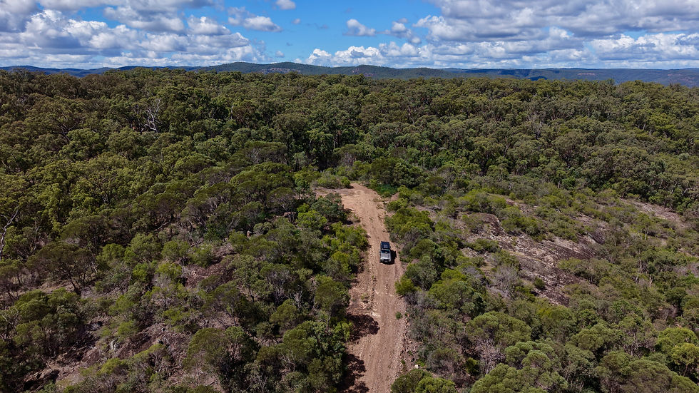
At certain points along the way there are steep climbs, switchbacks and blind crests which will keep you on your toes. Allow 2 hours to get down to the parks boundary and another hour to get to out to civilisation, towing is prohibited for these reasons and it’s regarded as the parks most isolated track. Parks Queensland will close it during wet weather.
HEADING DOWN RAZORBACK AT KROOMBIT HEADING ALONG RAZORBACK AT KROOMBIT WARNIN G SIGN FOR RAZORBACK TRACK
My trip ended out at Biloela which is a service town for local mines, but there’s plenty to see and do in its region, the towns Heritage centre must be visited to delve into local history.
BILOELA HERITAGE CENTRE BILOELA TANK ART INSIDE BILOELA HERITAGE CENTRE
WHERE
Kroombit Tops NP is 400km north west of Brisbane or 100 south east of Gladstone in QLD. Access is available from the North, west and south depending on your vehicle. The nearest towns are Biloela and Monto both around 60km away.
WHAT’S IN THE AREA
It’s a remote and isolated park where you can experience isolated camping, visit a WW11 plane crash and tackle the 4wd tracks. The towns of Monto and Biloela have heritage centres and museums focusing on local history, both geological and early settler. Kroombit Tops has a cool climate all year round as the elevation is nearly 900m above sea level, with the highest point at 940m called Amy’s Peak. It’s a rough and ruggered area with exposed sandstone cliffs and often regarded as an inhospitable mountain area. The main attraction at Kroombit is visiting the WW11 Bomber crash site.
MONTO WELCOME SIGN COW ART AT MONTO LOGGERS
TRACK DIFFICULTY
Conventional SUV’s can access Kroombit from the north along Tablelands Road, it’s also suitable for towing. The Razorback Track to the west down to Biloela is for high clearance 4wds, towing is prohibited and may be closed in wet weather by Queensland Parks. Coming from Monto and along Mahoon Creek Road, it’s also recommended for high clearance 4wds as there are many creeks to cross and the last section into the park up Clewleys Gap is a steep and rocky climb. Towing is allowed with decent offroad trailers. The 4wd tracks within the park are fine in the dry, but if they are wet, low range will be needed.
TRACK UP TO KROOMBIT TOPS TRACK THROUGH KROOMBIT TOPS TRACK DOWN RAZORBACK TRAIL
OTHER LOCAL INFO
There are several camping areas in Kroombit NP, the main area called Griffiths Creek is a good base to explore the park with large grassy areas, fire rings, a dump point and non-potable water taps. There are no toilets here so come prepared. Razorback camping area has limited sites and has no facilities at all. Kroombit Tops lookout has spectacular views to the east and has a pit toilet. The nearest towns of Biloela, Monto and Calliope all have enough facilities to stock-up and prepare before heading to Kroombit. They have Heritage centres and local attractions to keep you busy in the area. Campsite booking need to be done online at https://parks.qld.gov.au/parks/kroombit-tops/camping . The walk into the WW11 crash site is suitable for anyone with a moderate fitness level and is heritage listed.
OLD STAMPER NEAR MONTO PLANE WRECK IN KROOMBIT TOPS STEAM GEAR NEAR KROOMBIT TOPS

Loved the historical story about Monto😂